

CALL ME ISHMAEL
Whale tracking and migration have been widely discussed in academia. Outside of research, those topics and more have trickled down into some of our favourite documentaries like Blue Planet.
In our attempts to better understand whales, scientists adopted the use of satellite imagery for tracking them. Some of the earliest applications can be found in a 1999 study published in Marine Mammal Science, and again in 2019.
So the next logical question would be: what more can be said on the matter of satellite imagery?
The Fulcrum spoke with PhD student Matus Hodul from the department of geography, environment and geomatics, who co-wrote the study “Individual North Atlantic right whales identified from space” alongside U of O professor Anders Knudby.
For background, remote sensing broadly refers to the subject field of using satellites, aerials, aeroplane photography, or even drones to obtain information via sensors. It is important to note that the actual instrument that’s on the satellite, drone, or aeroplane can be anything. However, in this case, researchers opted for optical.
Optical Satellite Imagery
According to Hodul, the type of imagery utilized in this study is called Worldview-3, “an optical sensor on a satellite and it gives us multispectral imagery. Meaning that it not only shows us the red, green and blue bands (RGB), like a normal DSLR camera. It also shows a little bit into the ultraviolet range and a lot of near-infrared data or near-infrared light coming off of the ground. In our case, we are just using the RGB right now.”
Common obstacles and considerations
When asked about some issues unique to satellite imagery, Hodul elaborated on clouds being a huge factor. This is unique because other techniques, like radar and sonar, are not affected by clouds and can collect data regardless.
“Reflection off the water is another problem. It’s called glint — and if it’s really sunny, and if the angle of the sun and the angle of the sensor of the satellite are inopportune — then you’ll get a lot of reflection off the water,” added Hodul.
For this study, he noted that they were extremely lucky to have experienced a combination of ideal conditions; there was an absence of clouds and waves that would otherwise obscure the viewing of the whales. In addition researchers were able to avoid glint altogether.
Identifying whales
Hodul explained that the model identifies whales based on shape.
“In the same way that you might look at a tile and see that there’s a whale there based on your understanding of whale shape — that it’s kind of long and thin, and it’s got the tail at the end, and just kind of got a white pattern on its head. The model looks at all that and tries to differentiate a whale from open water. It’s very easy because the open water is simply blue.”
Researchers are able to ‘teach’ the model to understand and differentiate between what is and isn’t a whale by feeding it thousands of images of whales and thousands of images of objects in the open ocean that resemble whales, like boats and logs. As the model progresses, it learns to predict which shapes are whales and which are not based on colour and other patterns.
“Marine remote sensing is especially tricky when it comes to a half-submerged whale with only its head sticking out, because now it looks completely different than a fully uncovered whale where you can see it head to tail. So, that could potentially throw off the model,” added Hodul.
Research Methods
In terms of research, “the satellite imagery itself can be tasked, meaning you can tell the company where and when you want them to capture the satellite imagery. We knew where the whales were going to be because they’re a migratory species, and every April, they spend a week or two in Cape Cod Bay. When we had confirmed sightings of whales in Cape Cod Bay from field observers, then we knew it was time to start taking the imagery using the satellite company.”
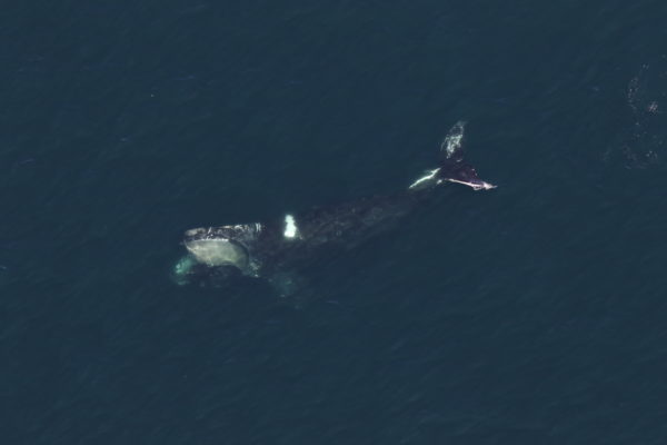
Hodul continued, “On the day we recorded imagery, there were roughly 40 whales in the area. Now, at the same time, we had the field team, which runs out of the Centre for Coastal Studies in Cape Cod Bay who was able to get the field data, which included the physical location of each whale that they observed, and also the aerial photography of the whales — which is how we were able to get those really nice shots of the aerial photos taken from the aeroplane.”
In essence, researchers were trying to have their space imagery as similarly matched to their field data as possible.
Worldview-3 has a resolution of 0.3 metres to 30 centimetres. If you look at an image, each pixel in the image is 30 centimetres by 30 centimetres squared, roughly the size of a dinner plate. Although researchers could, in theory, see whales in the 30-centimetre imagery, they’re often blurry and it is difficult to differentiate whales from other objects on the ocean.
However, this year the company released a new kind of imagery from the same satellite that’s 15 centimetres. It’s what was used in the paper and produces much higher-quality images. Thus, establishing Hodul to be the first to identify whales using the 15-centimetre imagery.
At that point, researchers had both satellite images and aerial images taken in the field. Now, it was only a matter of matching up the respective images, which according to Hodul, is difficult because the satellite images are taken almost instantaneously whereas the field data taken from an aeroplane spanned over five to six hours.
“The whales moved between when they were observed in the satellite image versus when the field crew got around to spotting it. Since it’s not an exact one-to-one match, we had to come up with some sort of spatial tolerance. Meaning, if you observe a whale in the satellite imagery, how close to the observation in the field can it be to still consider it as an accurate spot of a whale,” he explained.
Moving forward, researchers are hoping to develop more automated systems. However, for this published research, they had a more manual approach, which meant they were able to capture and count around 33 confirmed spotted whales in the satellite imagery.
Future applications
Hodul foresees numerous applications for satellite imagery to be used for conservation efforts. One spatially acute issue mentioned is the mortality threats partially caused by whales getting hit by ships and tangled with fishing gear.
“Another issue for whales are lobster traps, where a whale may swim through it and get hooked and tangled on the vertical lines. However, if we could use satellites in near real-time, to determine where the whales are, we can reroute ships or slow them down or have them move the fishing gear,” said Hodul.
Currently, whales are spotted by using aerial surveys and hydrophones to listen to where they’re located in order to reroute ships. However, Hodul mentioned those methods are not as accurate and they don’t cover very much space. Compared to a satellite image which can cover massive amounts of space all at once.
The industry is looking to expand whale detection capability outwards. Hodul is in the process of developing the system for detecting whales, and then the policymakers are going to use the tool to be able to reroute ships and fishing gear.